Darwin heading for hottest day of the year: the forecast that exposes a late-wet-season paradox
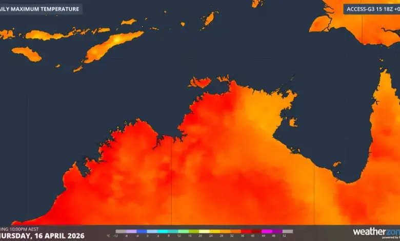
Darwin is forecast to reach 36°C this Thursday, a mark that would make it the hottest day of 2026 to date by well over a degree. The number matters because it cuts against a common assumption: late wet season conditions should be easing, yet Darwin is heading for a peak that stands out even in a year already marked by heat.
What is driving the spike in Darwin?
Verified fact: the forecast maximum of 36°C is tied to clear skies and warm southeasterly winds. In the Top End, those winds do not behave like the southeasterlies that typically bring cooler or showery weather to other Australian capital cities. Here, they tend to carry warm, dry air from the interior of the Northern Territory.
Analysis: that difference is the core of the story. The same wind direction can mean one thing on the coast elsewhere and something entirely different in Darwin. The result is a forecast that looks out of place only if the local wind pattern is misunderstood. For Darwin, the heat is not an anomaly in the weather system; it is a product of it.
The timing also matters. The official Top End wet season runs from November to the end of April, but April is only a quarter as wet on average than Darwin’s rainiest month of January. That seasonal shift creates more clear-sky days late in the wet season, and Thursday is one of them. The forecast places Darwin at the center of a brief but intense window of heat before conditions begin to change again.
How do inland temperatures complicate the picture?
Verified fact: inland NT towns are not expected to exceed Darwin on Thursday. Katherine, about 300 km southeast of Darwin, is forecast to reach 36°C, while Tennant Creek, about 1000 km southeast of Darwin, is forecast at 33°C. That means Darwin could match or outpace places deeper inland that are often assumed to be the hotter locations.
Analysis: the comparison undermines a simple map of heat that treats inland areas as automatically more extreme. On this day, the coast is not being moderated by sea-breeze relief in the way many readers might expect. Instead, the forecast points to a heat setup in which Darwin sits alongside inland towns rather than below them. The local wind direction is doing the work.
This is why the forecast is significant beyond one number. It shows how regional weather can overturn everyday assumptions about geography. In the Top End, southerlies can transport dryness and heat rather than cooling moisture, and Thursday is expected to reflect exactly that pattern.
What else is affecting the Top End weather?
Verified fact: the remnants of ex-Tropical Cyclone Maila continue to affect parts of Queensland and are now also impacting Arnhem Land in the northeastern corner of the NT. Moisture is approaching the Arnhem Land coastline early on Thursday morning, and a stark contrast in relative humidity is visible across the Top End. Low-humidity air is shown with orange and yellow, while higher humidity is shown with greens and blues. The boundary between those airmasses is called a dry line.
Analysis: this places Darwin near a broader moisture transition rather than inside a uniform weather field. That matters because the forecast is not just about heat; it is about the meeting point between dry inland air and moisture drifting in from the northeast. The outcome is a weather pattern that can feel sharp and uneven across short distances.
A run of days closer to the April average maximum of 32. 8°C is expected in Darwin after Thursday, with showers and storms increasingly likely as moisture drifts westwards. That suggests the hottest day of the year may also be one of the clearest markers of a short-lived atmospheric shift. On one side of the dry line, the air is hot and dry; on the other, moisture is edging in.
What should the public understand about this forecast?
Verified fact: the forecast is not presented as a long-term trend, but as a specific late-wet-season peak followed by a return toward more typical April conditions. The contrast is immediate: 36°C on Thursday, then temperatures closer to the April average and a rising chance of showers and storms.
Analysis: the public should read the forecast as a reminder that Darwin’s weather can turn on small shifts in wind and moisture. The hottest day of 2026 so far is not simply a temperature story; it is a story about how the Top End’s late wet season can briefly amplify heat before moisture regains ground.
For readers tracking risk, discomfort, or daily planning, the key point is that the heat is being driven by a very specific pattern rather than a broad seasonal blanket. That makes the forecast precise, temporary, and locally important. It also explains why Darwin is expected to stand out on Thursday before conditions begin to settle back toward Darwin’s April average and the weather becomes more unsettled again.
The central question is not whether Darwin will be hot. It is why Darwin, on this day, can be hotter than expected while the surrounding region shifts under the same larger system. The answer lies in the wind, the dry line, and the late-wet-season setup that places Darwin at the center of the day’s most striking temperature contrast. That is the deeper meaning of Darwin.