The Met Office is pointing to a short-lived burst of spring warmth this week, with the warmest day arriving before conditions turn more unsettled heading into the Bank Holiday weekend. The signal is clear: dry and sunny weather dominates midweek, then rain and showers begin to push in from the south and west.
What Happens When the Warm Spell Peaks?
The latest forecast shows temperatures rising to around 23C on Thursday and 24C on Friday in southern areas, with northern areas expected to reach around 20C on Thursday and 23C on Friday. The same outlook says Wednesday and Thursday will be largely dry, with warm sunny spells, although it will be breezy in the south. By Friday, there is an increasing chance of showers moving in from the west.
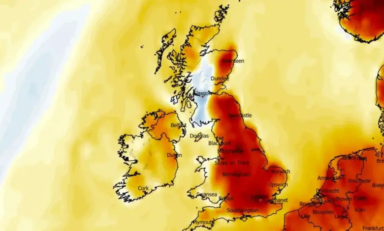
Temperature anomaly maps point to a broad area of unusually warm conditions on Friday, with the country covered in deep red shades that indicate values well above the average for this time of year. A separate weather model places Friday’s highs at around 22C, with the warmest readings in the south-east of England, including the London area. The maps suggest as many as 25 counties could see temperatures at 20C or above.
What If the Sunshine Holds Longer Than Expected?
That is the key uncertainty in the short-range outlook. The warmest readings depend on how long the dry, sunny conditions last before the showers spread in. If sunshine lingers into Friday, southern and central areas of England could feel particularly warm and humid. If cloud and showers arrive earlier, the peak warmth may be shorter and less widespread.
Tom Crabtree, Deputy Chief Forecaster at the Met Office, said conditions are expected to become more unsettled by Friday, with rain and showers spreading in from the southwest and some of them potentially heavy and possibly thundery. He added that temperatures could still reach 24C in central and southern areas before the pattern changes.
What Happens When High Pressure Starts to Give Way?
Midweek remains the bridge between two different weather patterns. High pressure supports largely dry and fine conditions on Wednesday and Thursday, but the developing change later in the week brings a more mixed picture. Rain and showers are expected to spread from the south and west, while clearer spells ahead of that rain may still deliver a warm feel in parts of England.
The same forecast warns that the weekend becomes more changeable, with showers at times and sunnier intervals also possible. That means the warm spell does not disappear entirely; instead, it becomes less reliable and more uneven across the UK. The broad message is a shift from calm spring warmth to a less settled pattern.
| Period | Expected pattern | Temperature signal |
|---|---|---|
| Wednesday to Thursday | Largely dry, warm sunny spells | Above average, breezy in the south |
| Friday | More unsettled, showers moving in from the west and southwest | Up to 24C in southern and central areas |
| Bank Holiday weekend | Changeable, with showers and sunnier intervals | Still mild at times, but less stable |
Who Gains From the Warm Surge, and Who Faces the Risk?
For people hoping for a bright midweek lift, the forecast is favorable: sunshine, dry weather, and temperatures well above average. Outdoor workers, commuters, and anyone with plans later in the week will benefit most from the drier stretch before Friday’s change. The warmth may also make Friday feel more summery than late April usually does.
By contrast, those needing settled rain patterns will see less immediate benefit. The forecast mentions showers, but it also suggests the rain may arrive in bursts rather than as steady, soaking conditions. That means the switch to unsettled weather may disrupt plans more than it helps ground conditions. The Met Office also notes that even cloudy conditions can still bring sunburn risk at this time of year, which keeps UV awareness relevant despite the mixed forecast.
What Should Readers Watch Next?
The next few days are less about a single dramatic event and more about a transition. The Met Office is signaling a midweek window of warmth before a gradual turn to more unsettled weather near the Bank Holiday weekend. The exact timing of showers will matter, because a few hours either side of Friday could change how widely the warmth is felt. For now, the practical reading is straightforward: enjoy the dry and sunny spell while it lasts, expect a shift late in the week, and keep an eye on the forecast as conditions evolve. Met Office