The mexico–united states border wall is entering a new phase as federal officials map possible routes through Texas state parks while publicly signaling that construction is on hold. That tension matters now because the gap between what was planned in documents and what has been said in public is shaping the next move for land managers, border communities, and conservation advocates.
What Happens When Federal Plans Meet Texas State Parks?
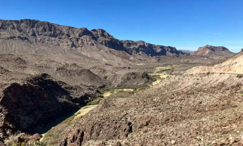
Documents obtained under the Texas Public Information Act show that Border Patrol had already traced a path for a border barrier through Big Bend Ranch, Seminole Canyon, and Bentsen-Rio Grande Valley State Parks before a March 6 letter told Texas Parks & Wildlife Department leaders that wall construction at state parks and Big Bend National Park was on hold. The maps included detailed routes within the parks, even as the agency later emphasized that its current focus is on high-traffic areas.
Those same records point to specific pressure points. In Seminole Canyon, the planned route could restrict access to ancient rock art on the Rio Grande. In Big Bend Ranch State Park, the maps place the project near the Grassy Banks campground and Contrabando Canyon. The federal agency has also updated an online map to show detection technology in the Big Bend national and state parks rather than a physical barrier, but agency leadership in Washington has not said the wall is off the table.
What If the Wall Becomes a Mixed Barrier-and-Technology System?
The current pattern suggests a shift from a simple yes-or-no wall debate to a more layered border strategy. Paul Enriquez, director of the Border Patrol’s infrastructure portfolio, said in an email that construction on TPWD land and at Big Bend National Park is not a priority right now, but he did not rule out future action. He wrote that these areas will eventually be reviewed to determine whether to implement a barrier, roads, and/or technology.
That leaves three visible signals in place at once: a formal pause, continued mapping, and an unresolved final decision. For readers trying to assess where this heads next, the mexico–united states border wall debate is no longer only about steel or fencing. It is also about access, surveillance, and how much discretion federal agencies preserve when public resistance grows.
| Scenario | What it means | Who feels it first |
|---|---|---|
| Best case | State parks remain outside active construction plans, with detection technology taking priority | Park visitors, local residents, conservation groups |
| Most likely | Federal officials keep plans unsettled while reviewing barrier, road, and technology options | Texas Parks & Wildlife Department, border communities |
| Most challenging | Construction proceeds in or near park land despite public opposition and mixed federal messaging | Park access, cultural sites, nearby communities |
What If Public Pressure Continues to Shape the Map?
Public outcry has built since early February, when plans for a border wall through Big Bend became public. A protest is scheduled outside the Texas state capitol on Saturday, April 4. That response has already coincided with a changed public map, which now shows detection technology in place of a physical barrier in the Big Bend national and state parks.
Still, the underlying record is not settled. The federal agency did not answer questions about requests for access to state parks, and TPWD referred those questions back to CBP. That circularity matters because it keeps the decision-making process opaque at the exact moment when affected communities are looking for clarity. In practical terms, the mexico–united states border wall is now as much a governance story as a construction story.
Who Wins, Who Loses, and What Comes Next?
Potential winners include agencies that can delay a direct construction commitment while preserving flexibility, and officials who prefer a technology-first approach in sensitive areas. Potential losers include park users, cultural heritage sites, and local communities that must live with uncertainty over access, traffic, and landscape disruption.
The clearest takeaway is that this is a live planning conflict, not a closed decision. Federal documents show active route tracing, public statements show a pause, and the public record shows no final reversal. Readers should watch for whether the next official signal confirms long-term restraint or reopens the door to construction in parkland. For now, the mexico–united states border wall remains a moving target, and that uncertainty is the story.