London Weather and a Snow-Covered Roof: How Wintry Air Is Returning to the UK and to People’s Lives
A snow-covered roof in East Kilbride, South Lanarkshire stood out against a low, grey sky as commuters negotiated slushy pavements — a small, visible sign that the cooler pattern sweeping the country has teeth. For those watching forecasts in the south, the question on many lips is what this burst of Arctic air will mean for london weather as blustery showers and wintry returns spread across the UK.
What does the return of wintry weather look like on the ground?
In the north, it already looks wintry: parts of Scotland, including the central belt, saw a covering of snow through a morning rush hour, and snow showers remain likely over the hills in Scotland and Northern Ireland. The pattern is a mix of sunny spells and blustery showers, with hail and occasional thunder where the atmosphere is most turbulent. Overnight and early-morning frost has been noted in northern areas, while south-eastern areas began the period relatively mild and have struggled to reach double-figure daytime temperatures elsewhere.
Where will London Weather and the rest of the UK feel the worst of it?
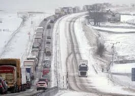
Direct impacts are concentrated away from the capital. The Met Office has put warnings in place for parts of Scotland, with a yellow weather warning for snow and ice covering areas north of Stirling and around Fort William. A Met Office forecaster said, “Blustery wintry showers will affect central and north-west Scotland during Thursday afternoon and evening but are expected to become more frequent during the second half of the night before easing on Friday morning. Two to 5cm of snow is expected fairly widely across the area, with 10cm possible in places above about 350 metres. “
Wind warnings accompany the snowfall threat. Gusts of 50-55mph are expected widely in Scotland and England, with some coastal areas and places downwind of high ground potentially seeing gusts of 60mph or even 70mph. Authorities have warned that these conditions may cause delays to road, rail, ferry and air transport and may bring short-term loss of power and other services.
How are services and communities responding?
Transport operators and infrastructure managers are actively adjusting operations. ScotRail warned passengers that journeys may take longer after Network Rail Scotland placed speed restrictions on several routes, including the West Highland Line, the Highland Main Line and the Far North and Kyle Lines. Some ferry services on Scotland’s west coast operated by Caledonian MacBrayne have been disrupted by the windy conditions. In one local incident in Aberdeenshire, the A90 was temporarily blocked in both directions at Fordoun when a fallen power line lay across the carriageway; that obstruction was cleared later.
The colder air is expected to linger into the weekend with further frosty nights in Scotland and Northern Ireland and a continued risk of wintry showers on higher ground in the north. Saturday should start frosty but with sunshine in places before showers become more numerous by afternoon; Sunday looks windier with more frequent showers and a renewed chance of wintry conditions in the north by Sunday night. The situation is linked to a strengthened jet stream that has drawn cold Arctic air southwards; forecasters trace the jet stream’s recent strength to a sharp temperature contrast between warm air and Arctic air further west.
Practical steps already taken by agencies include issuing yellow warnings for snow, ice and wind and putting speed restrictions in place on vulnerable rail routes to protect passengers. Ferry operators have adjusted timetables where conditions made crossings difficult. Local authorities have had to respond to isolated incidents caused by the wind and snow, including temporary road closures.
Back beneath the low clouds in East Kilbride, a resident who shoveled their pavement said the morning commute had been slowed but that neighbours were checking on older residents and sharing grit. That small neighborhood response reflects the wider pattern: most disruption so far has been managed by transport bodies and local crews, while the weather itself has served as a reminder of how quickly conditions can change.
As people in the south consider london weather in the coming days, the direct effects for the capital are likely to be muted compared with the north, but the broader pattern of chilly air and blustery showers will be felt in varying degrees across the UK. The cold spell is expected to gradually ease early next week, with temperatures recovering to a little above the mid-March average.
Returning to the snow-lined street in East Kilbride, the scene that began the day now reads as part of a national story: localized disruption, targeted warnings, and communities adapting to short, sharp brushes of wintry weather — while many in the south continue to watch how london weather will follow the arc of the jet stream in the days ahead.