The road report across northern Ontario is turning into a flood alert story, with one city closing a key street and another widening its warning to cover all watercourses and major rivers. The shift matters because the combination of snowmelt, rising temperatures, and recent rainfall is moving conditions from watchful to active disruption.
What Happens When Water Keeps Rising?
In Sault Ste. Marie, Frontenac Street is closed to all traffic from the entrance to Northland Trailer Park to Tecumseh Street because of flooding. The closure takes effect immediately and remains in place until water levels recede and the roadway is considered safe for travel. Local traffic and area residents are being urged to use alternate routes and exercise caution.
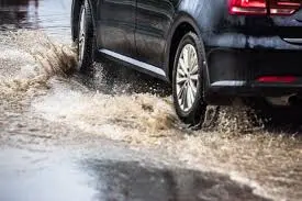
Municipal crews are monitoring the situation and will provide updates as conditions change. The public is also being reminded not to drive through flooded roadways, since water levels and road conditions can be unpredictable. In practical terms, the road report is no longer about isolated pooling; it is about roads becoming unsafe enough to shut down.
What If the Flood Warning Keeps Expanding?
In Greater Sudbury, Conservation Sudbury expanded a flood warning on Wednesday to include all watercourses and major rivers, effective at 2 p. m. and in place until April 22. The warning now covers rising systems including Onaping, Vermilion, Whitson, and Wanapitei. The authority says water levels in smaller watercourses are elevated, major systems are rising steadily, and overland flooding is already occurring in numerous low-lying areas.
The warning also includes localized ponding on streets, which is expected to continue. Areas named in the notice include parts of the Flour Mill adjacent to Junction Creek, Nickeldale north of the Ponderosa wetland, Charlotte Street adjacent to Junction Creek, Beverly Drive near Lily Creek, areas of Coniston adjacent to Romford Creek, and areas adjacent to Moose Creek in Wahnapitae. Added to the warning are Riverbend Road adjacent to the Wanapitei River, Larchmont Drive, Carol Road, and Grassy Lake Road along the Vermilion River, the Vermilion River bridge on Desmarais Road, and low-lying areas in Dowling along the Onaping River.
What Forces Are Driving the Current Road Report?
The pattern is clear: continued snowmelt, warming daytime temperatures, and recent rainfall are all feeding the rise. Conservation Sudbury says the remaining snowpack across area watersheds still holds roughly double the seasonal average in water content. As that snowpack melts, water is being released into systems already under pressure.
The forecast for the next four days points to continuous warm weather, with daytime temperatures ranging from 11 to 17 C. Additional precipitation is also possible, with forecasts calling for another 10 mm on Thursday evening and up to 20 mm this coming Saturday. That combination is why the authority says water levels in many watercourses are extending beyond the top of banks and spilling into adjacent neighbourhoods and streets. It also says the area of flooding is expected to be greater than what was seen in spring 2023, and that levels similar to the 2023 freshet event could be met or exceeded in the next 1-2 days.
| Area | Current condition | What it means |
|---|---|---|
| Sault Ste. Marie | Frontenac Street closed | Traffic detour and safety risk from flooding |
| Greater Sudbury | Flood warning expanded | All watercourses and major rivers under alert |
| Low-lying neighborhoods | Overland flooding and ponding | Continued street and property disruption |
Who Wins, Who Loses, and What Should Residents Expect?
Residents in flood-prone areas lose the most immediate access and certainty, especially where roads, bridges, and low-lying streets are already affected. Local traffic, commuters, and emergency planning all become more complicated when routes are closed or when streets collect standing water. Municipal crews and conservation staff gain a clearer mandate: monitor, update, and keep people away from dangerous areas.
The key risk is not only flooding itself but the speed at which conditions can change. Children near creeks and rivers are specifically flagged as a concern, and the message is consistent across both places: avoid cold, fast-flowing water, avoid slippery stream banks, and do not attempt to drive through flooded roadways.
For readers tracking the road report, the main takeaway is straightforward: the situation is active, localized, and still evolving. Expect more closures, more ponding, and more warnings if the warm weather and added precipitation continue. For now, the best response is patience, alternate routes, and close attention to official updates as the water recedes or spreads. That is the current road report.