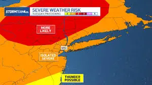
By late afternoon, the sky over Burlington was already shifting into a more unsettled mood, and the word many residents were watching for was thunderstorm. Tuesday brings showers and thunderstorms across the region, with the strongest storms most likely south of Route 4 in southern Vermont, where a Severe Thunderstorm Watch remains in effect through 10 p. m. ET for Rutland, Windsor, Bennington and Windham counties.
What does the watch mean for southern Vermont Tuesday evening?
The overall severe weather threat is low, but the setup leaves room for a few stronger storms. The warm, moist air south of the region, combined with increasing instability through the afternoon and evening, is creating conditions that can help thunderstorms develop and strengthen. The biggest concerns are damaging wind gusts and heavy downpours, especially later in the day.
The Storm Prediction Center has placed the area under a slight risk for severe weather, a sign that the most widespread danger is limited even as scattered storms may still turn stronger. In that pattern, not every community will see the same conditions. Some areas may only get brief rain, while others face more intense weather in a short window.
Where are the stronger storms most likely?
The strongest storms are most likely in southern Vermont, particularly in Rutland and Windsor counties and points south. That is where the atmosphere is expected to be most favorable for development. Thunderstorms will be most likely during the late afternoon and evening hours Tuesday, when heating has had more time to build instability.
If storms do strengthen, gusty winds above 58 mph are the main concern. Small hail is also possible in a few cells, though damaging hail and tornadoes are not expected with this setup. A very brief, weak spin-up is not ruled out, but it is not the primary risk. The broader threat remains heavy rain, which can fall quickly in a moist air mass.
How should people in the watch area think about the risk?
This is a day for attention, not alarm. The watch does not mean every town will see severe weather, but it does mean conditions are being monitored for storms that could become hazardous. For people in southern Vermont, the message is simple: keep an eye on the sky as the afternoon turns to evening, and be ready for changing conditions.
That matters because severe weather can move from a passing nuisance to a fast-moving problem. Wind damage can happen quickly, and heavy downpours can reduce visibility and make travel more difficult. The weather may stay quieter in one town while another nearby sees a stronger cell develop.
What is being done to keep residents updated?
Weather monitoring is already active through Tuesday, with updates expected as conditions evolve. Residents in the watch area are being urged to stay weather-aware and follow changes through the day. The goal is to give people enough time to respond if a warning is issued later on.
For many households, that means the evening could feel less like a routine Tuesday and more like a waiting game. The thunderstorm risk is not described as widespread or extreme, but it is enough to keep southern Vermont on alert until the watch expires at 10 p. m. ET.
By nightfall, the sky may look no different from the one that opened the day: warm, unsettled, and ready to shift again. For now, the safest plan is to watch the weather as closely as the weather is watching back.