Windy weather is building across southern and southeastern Australia as a deep low pressure system over the Southern Ocean strengthens and pushes northward. The system is set to shape conditions through the rest of the week, bringing rain, storms, strong winds, heat, then colder air and autumn snowfalls in some higher and colder areas by the weekend.
Rain and storms move in first
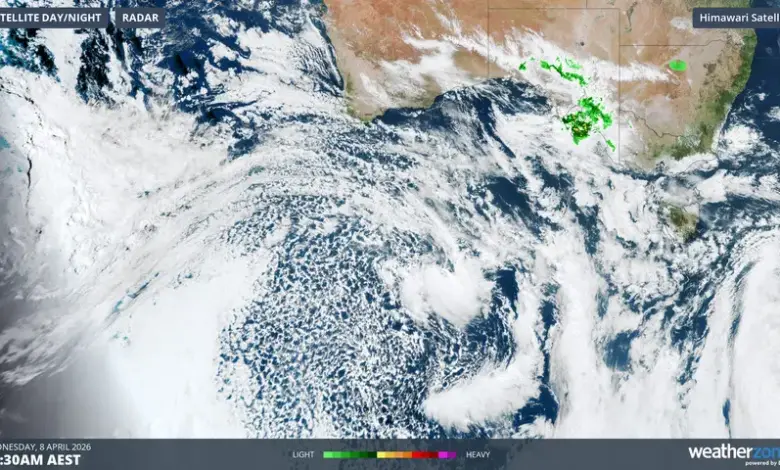
The first impacts are already being felt across southern parts of South Australia, where rain and storms are moving through ahead of the main system this Wednesday ET. A pre-frontal trough will then drive showers and storms eastward into Thursday ET, spreading the unsettled pattern farther across the south.
Adelaide sits in the middle of the immediate forecast focus, with the chance of a useful soak still uncertain. The city had just 17. 8 mm of rainfall across three months of summer, then recorded 37. 8 mm in March, while much of South Australia saw near-record or record-breaking totals in what was the state’s second-wettest March on record.
Windy Weather peaks ahead of the front
Forecast maps point to the strongest winds arriving ahead of the main cold front, when the pressure gradient tightens and cold air pushes warm air upward. The first cold front is due over the southeast on Friday morning ET, and widespread wind gusts of 89 km/h or higher are possible in parts of southeastern Australia.
Weatherzone meteorologist Yoska Hernandez flagged the system on Easter Monday, and the situation has now moved close enough for its effects to be breaking through in real time. The same system is expected to swing from warm conditions to sharply colder air as it moves through the region.
Severe thunderstorms remain possible
Severe thunderstorms are possible across parts of southern South Australia, Victoria and southern New South Wales, especially on Thursday ET. The exact placement of the heaviest rain and strongest storms remains uncertain, but the broad setup favors a volatile mix of showers, storms and damaging gusts as the front approaches.
The broader pattern is being driven by a deep low pressure system associated with a polar airmass over the Southern Ocean below Western Australia. As it surges northward, it is expected to dominate the weather across the south and southeast for the remainder of the week, bringing a sharp contrast in conditions from one day to the next.
What happens next
By the weekend ET, colder air should settle in behind the front, and autumn snowfalls are due in parts of Victoria, New South Wales and Tasmania. More warnings could follow if the system intensifies further or if the strongest bands of showers and storms line up over populated areas.
For now, the headline remains the same: windy weather, rain, storms and a sharp cooldown are all on the way as the system moves deeper into southern Australia. The exact timing and severity will continue to matter through the next several days of windy weather.