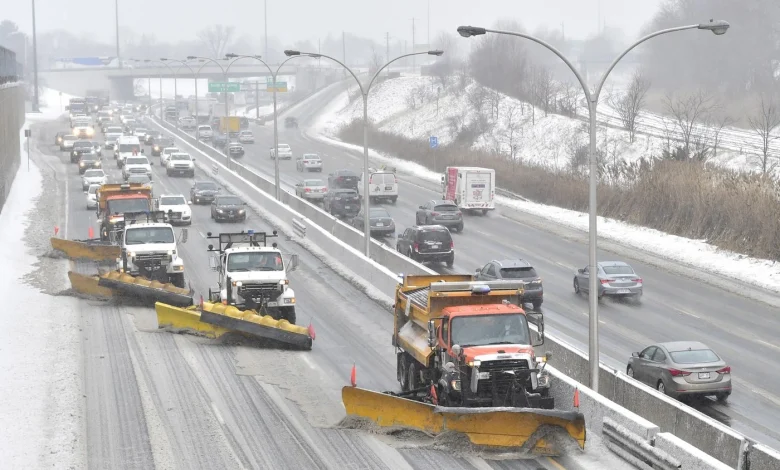
Despite a mild start to the week, environment canada forecasts a sudden return to wintry conditions that could reshape Friday’s commute across the Greater Toronto Area. A fast-moving Alberta clipper will deliver widespread flurries, localized bands of heavier snow and strong southerly winds, producing sharp contrasts in snowfall totals from near-lake zones to higher elevations. Motorists and municipal crews alike face a fast-changing set of hazards that may include slippery roads, blowing snow and mixed precipitation later in the day.
Background & context: The Alberta clipper and why it matters
The system driving Friday’s changes is described in forecasts as an Alberta clipper, a compact low-pressure system that typically moves rapidly from the Prairies toward the Great Lakes. That pattern favors quick bursts of snow and strong winds rather than prolonged heavy snowfall. Environment Canada’s outlook highlights that southern Ontario will see a range of outcomes: some GTA locations are expected to pick up three to five centimetres of snow, while pockets in northern York and Durham regions could receive up to 10 centimetres. Areas closer to Lake Ontario may see lower accumulations as air temperatures hover near freezing and some melting is likely to occur.
Environment Canada forecasts and hazards
Environment Canada has flagged both snowfall and wind as key concerns. Short periods of higher snowfall rates — noted as two to four centimetres in an hour in some advisories — can quickly coat untreated surfaces and create slippery roads. The agency’s broader guidance projects totals varying by location: many parts of southern Ontario can expect 5–10 centimetres, with a broader swath seeing 5–15+ centimetres by Saturday morning. Along the lakeshore, including central Toronto and Hamilton, precipitation may mix with rain, reducing final snow totals but complicating surface conditions. The heaviest accumulations are expected over higher terrain, such as the Oak Ridges Moraine.
Wind is a parallel hazard. Forecast notes indicate gusts climbing into the 50–60 km/h range in some spots, with stronger southerly winds developing later. In other regions the strongest gusts are expected to reach as high as 70–90 km/h, creating potential for reduced visibility from blowing snow and localized power outages where gusts are strongest. Environment canada emphasizes that even modest totals can produce hazardous travel when combined with those gusts and short-lived intense snowfall rates.
Expert perspective and what to expect on the ground
Jessie Uppal, CityNews meteorologist, characterizes the wind threat as significant for the region: “Winds will also be picking up throughout the day on Friday with gusts over 50 or 60 kilometres an hour. ” That combination of wind and snow is likely to slow evening commutes across southern Ontario, with traffic slowdowns and reduced visibility listed among the main operational impacts. Forecasters are also watching a separate system later in the weekend that could bring multiple precipitation types; current guidance notes the possibility of snow, ice pellets, freezing rain and plain rain in the days ahead, adding uncertainty for municipal response plans and travel advisories.
Operational concerns cited in forecasts include rapidly changing road conditions as snowfall rates fluctuate, the chance of wet snow near the lakeshore that can weigh on trees and power lines, and the potential need for quick changes in travel planning as precipitation mixes or temperatures cross the freezing mark. Drivers are advised to expect deteriorating conditions during the afternoon and evening and to prepare for slippery surfaces even where total snowfall appears relatively modest.
Regional ripple effects and preparedness
Impacts will not be uniform across the region: while central lakeshore communities may see lower snow totals, inland and elevated corridors from the Huron shores through Kitchener-Waterloo and the 401 corridor could experience a wetter mixture and notable accumulations. The Hamilton and Niagara areas face a heightened wind threat, with gusts that could lead to outages and travel disruptions late Friday into the evening. Municipal plows, transit operators and road crews will be balancing treatments for both snow accumulation and freezing or mixed precipitation where temperatures hover near zero.
With forecasts indicating a brief return to cooler conditions followed by an unsettled weekend, public officials and residents are being urged to monitor updates, prepare contingency travel plans and allow extra time for commutes. Short, intense bursts of snow and high winds can create outsized disruptions compared with cumulative totals.
As the clipper moves through and attention shifts to a follow-up system later in the weekend, environment canada’s advisories will remain the primary operational guide for decisions about travel, municipal response and public safety. How effectively communities adapt to rapidly changing precipitation types and wind conditions will determine whether Friday’s episode is a brief nuisance or a more disruptive weather event — and what the next system will produce remains the central question for planners and commuters alike.
image_url: null