extreme weather is about to test a broad stretch of the Midwest and Mississippi Valley again on Monday, after days of damaging storms already carved across the South and central U. S. The setup matters because forecasters are signaling a volatile atmosphere, with new storms likely to form along and ahead of an advancing cold front and dryline during the afternoon ET window.
What Happens When the Atmosphere Turns Volatile?
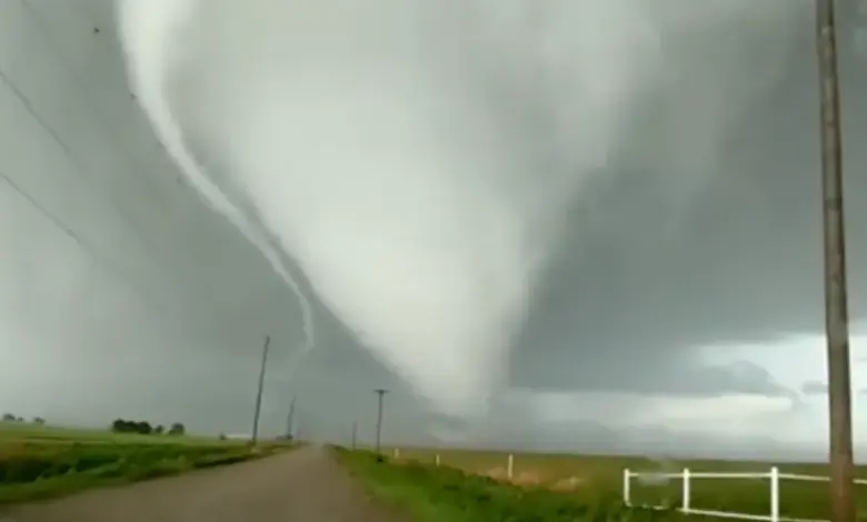
The immediate concern is not just rain or wind, but the full severe-weather package. The forecast points to all hazards being possible, including large hail, damaging winds, and tornadoes. The most serious version of this threat includes long-tracked, strong tornadoes, which is why the wording around Monday is so firm. For communities in the threat area, the question is no longer whether storms will form, but how intense they become once they do.
The scale is significant. More than 50 million Americans across the Midwest and Mississippi Valley are in the threat zone for the brewing outbreak expected Monday. NOAA’s Storm Prediction Center has placed parts of the region under a level 3 out of 5 risk, covering eight states including Missouri, Wisconsin, and Iowa. St. Louis is singled out as a place that could see some of the greatest impacts.
What If the Severe Weather Outbreak Expands?
This system is arriving after several days of severe weather already hit the South and central U. S., bringing numerous tornadoes, giant hail, and vicious winds. That recent damage matters because it shows the broader pattern: the atmosphere has been active, destructive, and capable of producing multiple hazard types in a short span of time. Monday’s outbreak would not be an isolated event, but part of a sequence that is still unfolding.
The current signal is being driven by an advancing cold front and dryline, which are expected to help trigger new storms through the afternoon. The FOX Forecast Center says those storms could become dangerous supercells capable of producing every major severe hazard. That is the key trend to watch: when the atmosphere is this loaded, one storm mode can quickly turn into a regional threat with little margin for error.
How Does the Recent Tornado Damage Shape the Outlook?
One reason the forecast is drawing attention is what happened in Enid, Oklahoma, where a confirmed EF-4 tornado tore through the city on Thursday evening. Local officials reported significant damage on the southern side, especially in the Gray Ridge area. At least 40 homes were damaged there, and some residents were trapped in homes and storm shelters after the tornado passed. Mayor David Mason said there were no fatalities and only minor injuries, despite the scale of destruction.
| Stakeholder | Likely impact Monday |
|---|---|
| Residents in the Midwest and Mississippi Valley | Potential exposure to hail, damaging winds, and tornadoes |
| St. Louis area | Could see some of the greatest impacts |
| Emergency managers | Need to prepare for fast-moving, multi-hazard storms |
| Already-damaged communities | Face added pressure if storms repeat in affected corridors |
What Happens Next for the Highest-Risk Areas?
Three scenarios stand out. In the best case, storms form but remain less organized, limiting the most severe impacts to scattered hail and wind. In the most likely case, the outbreak produces a mix of severe hazards across the threat zone, with some areas hit harder than others and St. Louis among the places watching closely. In the most challenging case, supercells organize efficiently and the environment supports strong tornadoes, creating a dangerous corridor of damage across multiple states.
extreme weather is not acting like a one-day event; it is behaving like a moving risk window that can shift quickly through the afternoon ET period. The practical takeaway is simple: the threat is broad, the hazards are serious, and the uncertainty lies in exactly where the strongest storms will track. Readers should treat Monday as a day for close monitoring, especially in the Midwest and Mississippi Valley, where the setup is already strong enough to support a major outbreak. The next few hours of forecast evolution will determine whether the day brings scattered severe storms or something much more concentrated. For now, extreme weather is the story, and the margin between a disruptive day and a dangerous one remains thin.