Wellington’s flood crisis has turned a day of heavy rain into a test of emergency readiness. New Zealand declared a state of emergency in the capital after torrential rain and flash flooding drenched the North Island, with the city recording 77mm of rain in less than an hour. The scale of the disruption has already pushed residents indoors, suspended normal routines, and forced authorities to prepare for more severe weather through the next day and a half.
Why the Wellington flood matters now
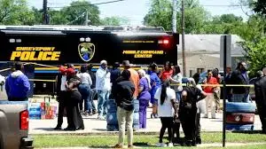
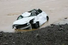
The immediate concern is not only the rainfall already seen, but the speed at which conditions changed. Vehicles were submerged, trees were uprooted, and houses were hit by landslides, while more than a dozen people were evacuated and a 60-year-old man was reported missing in the Karori suburb. No fatalities have been reported so far, but the flooding has already affected transport and education, with some flights at Wellington Airport cancelled and several schools shut.
Local authorities told residents to hunker down as the rain forecast pointed to another stretch of unsettled weather. The emergency management office for the Wellington region urged people in low-lying or flood-prone areas to consider relocating to friends’ or families’ homes for at least the next 24 hours. It also advised residents to cut or delay all non-essential travel. The Wellington City Mission has been set up for those needing shelter.
What the flood revealed about exposure and timing
The event stands out because of how quickly it escalated. Wellington Mayor Andrew Little said the city received a record 77mm of rain in less than an hour on Monday, calling attention to the force of the weather rather than just its duration. He said the city had seen flooding, slips and evacuations, and noted that the flooding was strong enough to move cars and lift manhole covers.
That intensity matters because flash flooding leaves little time for response. In Kingston, one resident described trying to escape on the back of his neighbour’s motorbike after a landslide buried a nearby road in the early hours of Monday. In Mornington, another resident said his garden had been inundated to the point where the grass could not be seen. These are not isolated inconveniences; they show how quickly a flood can convert ordinary streets and homes into unstable ground.
The timing also compounds the strain. This series of flash floods comes less than a week after Cyclone Vaianu swept through the North Island last weekend, creating a sense of repeated exposure rather than a single shock. Even without drawing conclusions beyond the current events, the pattern raises a practical question for emergency planners: how much repeated weather disruption can a city absorb before the margin for safe movement, shelter, and recovery narrows further?
Emergency response and public warnings
Mark Mitchell, the minister for emergency management and recovery, said the “worst of the weather” was expected later on Monday evening. He urged people in the Wellington region to be prepared, to make evacuation decisions early if needed, and to stay updated. That guidance reflects the central challenge of a flood emergency: the risk is not only what has already happened, but what could happen before the rain clears.
The official messaging has focused on early action, especially for those in vulnerable locations. The advice to delay unnecessary travel and move temporarily out of low-lying areas is designed to reduce the need for late rescues. It also signals that authorities are treating the current weather as an unfolding event rather than a finished one.
Wider implications for New Zealand’s capital
For Wellington, the immediate impact is a disruption to movement, schooling, and airport operations. But the broader significance lies in how quickly a city can move from severe rain to a multi-agency emergency posture. When landslides, cancelled flights, evacuations, and missing-person reports occur in the same weather system, the pressure extends beyond weather forecasts into public safety, logistics, and community support.
Research over the years has shown that climate change has made extreme weather events, including floods, more common and more intense around the world. That finding does not explain every local detail of this episode, but it does frame why scenes like this are being watched closely: they are part of a wider pattern that is reshaping how cities prepare for intense rainfall. In Wellington, the flood has become not just a weather story, but a live stress test of how a capital responds when ordinary infrastructure is overwhelmed.
Expert perspective and the road ahead
The clearest official voices in the current emergency have stressed urgency, caution, and relocation when needed. Andrew Little’s description of strong flooding that moved cars and lifted manhole covers underlines the scale of the impact, while Mark Mitchell’s warning about worse weather later on Monday evening points to a continuing risk window. Together, those statements suggest that the most important decisions may still lie ahead, not behind.
What happens next will depend on how much additional rain falls, whether evacuations increase, and how quickly roads and services can recover after the storm passes. For now, Wellington remains in a state of emergency, and the flood response is still being shaped by weather that has not yet finished. If the worst arrives as expected, how much more strain can the capital absorb before the emergency becomes something larger than one city can manage alone?