The winter storm warning pattern taking shape across California marks a clear turning point for the Sierra, where a real weekend storm is set to deliver a sharp return to wintry conditions from Saturday into Monday morning ET. The strongest impacts line up with the Tahoe crest and the central Sierra, while wind, snow levels, and snow density may matter nearly as much as the final totals.
What Happens When the Storm Peaks?
The most confident window runs from Saturday, April 11 through Monday morning, April 13 ET, with the wettest and windiest stretch from Saturday afternoon through Sunday morning. Snow is already underway or will begin quickly on Saturday, and early snow levels near 6, 500-7, 000 feet may allow mixed or heavy snow at lower Tahoe bases before colder air drives levels down into the 3, 500-5, 000 foot range Saturday night and Sunday.
That transition matters because the same storm is expected to produce dense snow at the front end before lighter, colder snow arrives later. Wind gusts around 40-55 mph on the Sierra crest and locally 60-70 mph near Mt. Rose point to a difficult upper-mountain period before conditions ease. For ski terrain, the deepest totals are centered on Kirkwood and Palisades Tahoe, with Mammoth in a smaller but still meaningful range and Mt. Rose on the lighter end because of its east-side exposure and stronger wind.
What If the Snow Totals Hold Near Forecast Levels?
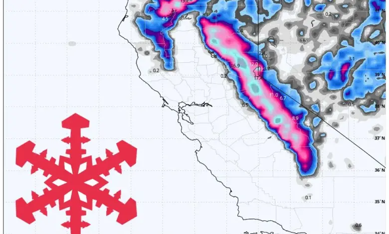
If the current structure holds, the Sierra will finish the weekend with a wide spread in snowfall by location. The Tahoe crest and central Sierra are positioned for the biggest payoff, while Mammoth is expected to land in the middle range and Mt. Rose comes in lighter. Mount Baldy only picks up a small amount of very dense summit snow and remains closed.
| Area | Expected snowfall through Monday morning ET | Key note |
|---|---|---|
| Kirkwood | 27-36 in | Deepest lift-served totals |
| Palisades Tahoe | 21-28 in | Major Tahoe crest payoff |
| Mammoth | 14-19 in | Solid but less extreme |
| Mt. Rose | 7-10 in | Weaker east-side result |
| Mount Baldy | 3-4 in | Dense summit snow; remains closed |
That spread shows how terrain, elevation, and storm positioning are shaping the event as much as raw moisture. Snow ratios are expected to start in the 6-10 range in Tahoe, which favors denser accumulation, then improve into roughly 11-15 by Sunday. Mammoth stays closer to 11-16, which supports a cleaner finish.
What Happens After the Weekend Storm Moves Out?
Lingering showers Monday morning should fade quickly, followed by a mostly dry Tuesday through Thursday ET. Cold mornings are expected in the teens and 20s °F at Sierra elevations, with afternoons recovering into the 30s and low 40s °F. Wind also drops off, creating a calmer middle stretch after the weekend surge.
That quieter break is important because it resets conditions before a weaker and far less certain system tries to return late in the period. The next wave, centered on Sunday night, April 19 into Monday, April 20 ET, carries lower confidence because the models diverge on timing, coverage, snow levels, and wind response. Some outcomes keep it weak or split apart, while others bring a modest Sierra refresh.
What If the Next System Strengthens Later in the Month?
The most likely path is another brush of unsettled weather after the dry break, not another major cycle. If that later wave holds together, the lower-end result could bring 3-6 in on the Tahoe crest, with lighter amounts south and east. Snow levels may begin high enough to make some base areas heavier at first before lowering with the front, and wind could range from merely breezy to another rough crest day.
For now, the broader pattern still leans cooler and at least somewhat active for California beyond midmonth, but the details after Friday should be treated as tentative. That uncertainty is the key forecasting limit: the weekend storm is well defined, while the later system is not.
Who Wins, and Who Faces the Hardest Conditions?
The clear winners are the Sierra’s favored west-side and central-crest terrain, especially Kirkwood and Palisades Tahoe, where the deepest totals are expected. Mammoth also stands to benefit from a solid snowfall event, though not at the same scale. Mt. Rose faces a tougher setup because of weaker totals and stronger wind exposure, and Mount Baldy remains on the edge of the event with only a small dense accumulation.
For travelers and mountain users, the main risk is not just snowfall volume but timing. The combination of rapid snow-level changes, dense early snow, and strong crest wind makes Saturday afternoon through Sunday morning ET the most operationally challenging window. The best takeaway is simple: this is a real weekend storm with a clear Sierra bias, strong local variation, and a quieter stretch to follow before the next uncertain signal arrives. For now, the winter storm warning remains a story of sharp contrast across the range, and winter storm warning conditions will be most consequential where terrain and timing align.