Northern Lights Aurora Borealis Forecast: Eyes Up as Bright Auroras Could Transform Canadian Night Skies
On a clear Canadian evening, people in towns and cities are being urged to look up: the northern lights aurora borealis forecast points to a chance of bright, colourful displays as a solar eruption heads toward Earth. Satellite imagery and space-weather models show the ingredients aligning for active skies during the nights ahead.
What happened on the Sun, and when will effects reach Earth?
On the morning of Monday, March 16, a moderate-strength M2. 7 solar flare erupted on the Sun’s Earth-facing side. Satellite images from the Solar Dynamics Observatory captured the eruption as it expanded away from the Sun and launched a coronal mass ejection (CME) toward Earth. Computer runs of the ENLIL solar wind model have been used to track that CME and indicate the first arrival around March 19, with additional clouds combining before reaching Earth early on March 21.
When the CME reaches Earth it is expected to disturb the planet’s magnetic field, producing a geomagnetic storm. Forecasters with NOAA’s Space Weather Prediction Center have issued a G2 (moderate) geomagnetic storm watch for Thursday night through Friday morning, March 19-20, with G1 (minor) and G2 conditions forecast through Thursday (ET) and G2 levels continuing into Thursday evening and overnight. Forecasts also note a potential resurgence of G1 followed by G2 levels Friday evening into Saturday morning should additional solar material and a fast solar wind stream arrive.
What does the Northern Lights Aurora Borealis Forecast mean for viewers?
The combination of the incoming CME and a Coronal Hole High Speed Stream (CH HSS) sweeping past Earth can set up stronger-than-normal space-weather activity. In practical terms, forecasters expect this pattern—especially occurring close to the March equinox—to increase the chances of brighter and more southerly auroras over the next two nights. Models show multiple CMEs approaching Earth, and when slower solar wind flows meet high-speed streams there can be a buildup of higher-energy particles along the transition, a dynamic that often enhances auroral displays.
How are scientists and forecasters responding?
Space-weather forecasters are monitoring the evolving situation with satellite imagery and model forecasts. The Space Weather Prediction Center is issuing watches and updating storm-level expectations as model runs refine the timing. NASA imagery and ENLIL model outputs are being used to visualize multiple CME clouds and the interaction with coronal hole flows. Those modelled interactions are what drive the public storm watch levels: G1 for minor disturbances and G2 for moderate disturbances to Earth’s magnetic field.
For observers, the immediate response is preparation: checking local skies for clear conditions and being aware that peak activity can shift as new CMEs and fast solar-wind streams combine. The forecast window mentioned by forecasters centers on the nights surrounding the CME arrivals and the passage of the CH HSS.
Back under the night sky, communities across Canada may see a familiar, uncanny green and red wash as solar particles tangle with Earth’s magnetic field. The precise timing and intensity remain dependent on how the incoming CMEs and the high-speed stream interact, which is why forecasters continue to update watches and model runs.
As people step outside and tilt their faces to the heavens, the question is simple and urgent: will the sky put on a rare, vivid show? The answer hinges on a still-moving stream of solar material and how it meets Earth’s magnetic shield—an unfolding event that could gift bright northern lights displays over the next nights, or fade as the streams miss their most active alignment.
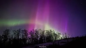
Image caption (alt text): northern lights aurora borealis forecast over a Canadian horizon