The Michigan Snow Storm is forecast in three distinct phases that will deliver heavy snow, near-zero visibility blizzard conditions, and localized crippling ice — while parts of the state face a simultaneous threat of rain-driven severe weather. This layered threat requires different responses from communities spaced a few dozen miles apart.
Michigan Snow Storm: How three phases will collide
Verified facts:
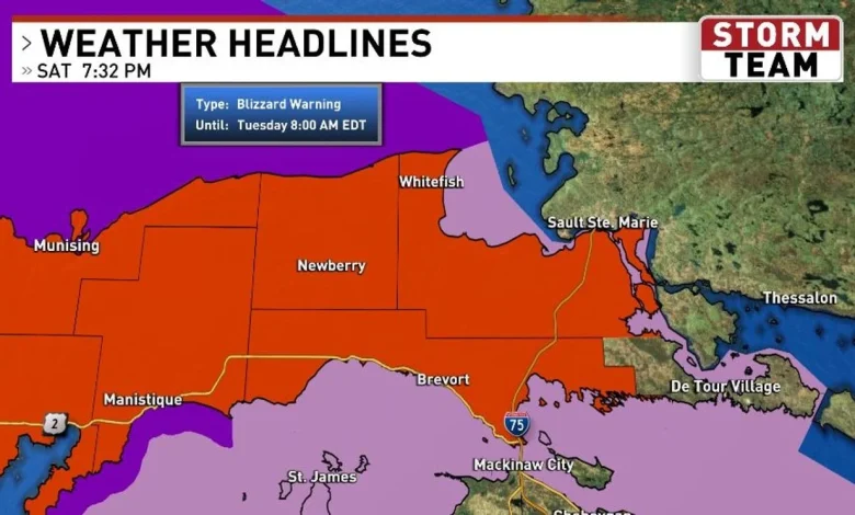
- Warnings and advisories: Winter Storm Warnings apply to the tip of the mitt in the northern lower peninsula; Blizzard Warnings cover most of the Upper Peninsula; Winter Weather Advisories cover much of the northern lower peninsula.
- Phase 1 begins with an initial burst of snow for most areas. Typical amounts are 3–6 inches with localized 8-inch totals overnight into Sunday morning; snowfall rates of 1–2 inches per hour and reduced visibility are possible.
- Phase 2 will remain mostly snow across much of the U. P. and the tip of the mitt with blizzard conditions and visibility near zero. Snowfall rates in these zones could reach 1–3 inches per hour. Near Drummond Island, some freezing rain could mix in.
- Significant icing is most likely in a corridor generally south from a Petoskey–Cheboygan line and north from a Manistee–Alpena line; expected ice accumulations in that corridor range from one-quarter to three-quarters of an inch late Sunday morning through early Monday morning.
- Areas farther south have the best chance of switching to mostly rain, with a marginal to slight risk of severe weather downstate. Damaging winds and large hail are highlighted as primary threats; an isolated tornado south of M-20 cannot be ruled out.
- Phase 3 brings a late re-entry of much colder air and very heavy snow back into most of the area, producing near-blizzard conditions. Some U. P. locations could see an additional 1–2 feet, with roughly 6–12 inches for most of the northern lower peninsula; amounts taper to the south and east.
- Timing details: The storm begins with snow Saturday night (mostly after midnight) with perhaps 1–2 inches overnight. Sunday features heavy snow for the Eastern U. P. /Straits/Tip of the Mitt much or all day, while portions of the northern lower may temporarily break before a freezing-rain wedge develops mid to late afternoon. Sunday night travel is expected to be nearly impossible areawide due to combined snow and ice. By Monday morning, freezing rain should transition to snow as colder air returns and winds increase.
What is not being told?
The verified forecast presents a clear physical picture, but it leaves critical planning questions unanswered. The same system is being described as a blizzard in the U. P. and a potential icing event in adjacent parts of the northern lower peninsula, while farther south the threat shifts to rain-driven severe weather. Community-level messaging and resource deployments often assume a single dominant hazard; this storm offers three different dominant hazards within short distances of one another. The forecast also notes that timing, track and amounts will likely vary with new model runs, underlining forecast uncertainty without mapping what those variations would mean for distinct communities.
Who is at risk and what must change now
Analysis (informed): Residents, emergency managers and transportation agencies face a complex challenge. U. P. and tip-of-the-mitt communities must prepare for near-zero visibility travel, high snow rates, and additional foot-plus accumulations. Northern lower corridor communities along the Petoskey–Cheboygan to Manistee–Alpena axis need focused preparations for ice accumulation that can render roads impassable and down electrical infrastructure. Southern and downstate areas must remain alert to damaging wind and hail, and the marginal tornado risk south of M-20 demands targeted shelter planning where rain will dominate.
Practical steps implied by the verified forecast include pre-positioning snow-removal and utility repair crews in distinct zones, issuing differentiated travel restrictions rather than a single statewide advisory, and communicating the specific local hazard (blizzard, ice, or severe rain) that households should prepare for. Because the forecast explicitly notes variability in timing and amounts, agencies should prepare contingency plans that scale for heavier snowfall and expanded icing ribbons.
The public record of the verified forecast makes one imperative clear: the Michigan Snow Storm is not a single uniform event and should not be treated as one. Transparency about which communities face which hazard, and quick, localized deployment of resources, are necessary to reduce harm as the system unfolds.