Ocean sensors and seasonal forecasts now show rapid changes in the equatorial Pacific: el niño signals have moved from a low‑probability backdrop to a scenario many models flag as strong or very strong. That shift forces a simple question: are global forecasts and national monitors telling the same story?
What ocean and model signals point to El Niño’s return?
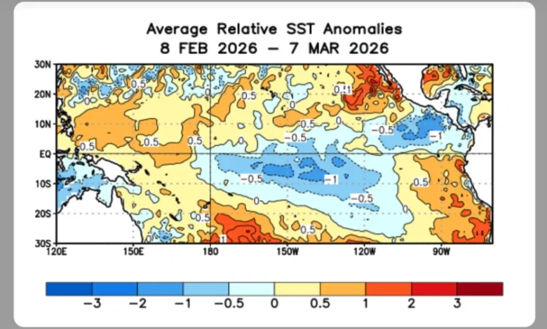
Several lines of evidence cited by seasonal forecasting centers indicate a quick transition in the tropical Pacific. Major seasonal models moved in a matter of days from a 60–70% chance of neutral ENSO conditions to a roughly 80% likelihood of a strong or very strong warm phase. Observationally, Kelvin waves have been transmitting subsurface heat toward the eastern Pacific and NOAA has identified significant subsurface warming – the classic early signal of a developing warm event. The Centro Europeo de Previsiones Meteorológicas a Medio Plazo (ECMWF) has published projections that similarly anticipate a developing El Niño, with model outputs pointing to a potentially strong episode if the current trends persist.
Why do national monitors and regional forecasters not all agree?
Discrepancies arise when global model ensembles and regional operational monitoring deliver different messages. In Ecuador, Commander Santiago Coral, Coordinator General of Oceanographic Affairs at the Instituto Oceanográfico y Antártico de la Armada del Ecuador (Inocar), emphasizes that current monitoring shows normal conditions in the Niño 3+4 and Niño 1+2 areas and that it is premature to declare El Niño for the country. In Chile, meteorologist Jaime Leyton of Mega characterizes the national expectation as a normal to moderate event rather than a strong one, and identifies probable impacts from Coquimbo to La Araucanía, with an elevated 60–70% chance of increased precipitation in central regions late in the season. At the same time, international model guidance from ECMWF and signals highlighted by NOAA point toward a rapid escalation in global probabilities. The contrast is real: model probabilities and basin‑scale subsurface heat versus on‑the‑ground regional monitoring that, right now, remains within normal ranges.
What would the consequences be if forecasts of a strong episode materialize?
Historical precedent underscores why this divergence matters. Historical analyses compare the present pattern of rapid subsurface warming and eastward heat propagation to the lead‑up to the 1997–98 super El Niño, an event widely treated as among the most disruptive in recent decades. Economic assessments of that event place its global damage in the trillions, a reminder that a strongly developing El Niño has outsized impacts on weather, agriculture and food security worldwide. Atmospheric teleconnections tied to El Niño typically produce drier conditions in some regions and much wetter ones in others, increasing the risk of both drought and extreme precipitation across different continents. Forecast centers note that ENSO development often begins in late April, with consequential atmospheric effects seen by September–October and peak impacts between November and March, making timely and coordinated preparedness essential if model projections verify.
What accountability and transparency are needed now?
The mismatch between global forecast ensembles and national monitoring invites clearer public explanation and coordinated contingency planning. Agencies with global remit, such as NOAA and ECMWF, are providing early warning signals based on subsurface heat and model consensus; national institutions like Inocar and regional forecasters are reporting the present observational reality and cautioning against premature conclusions. Policymakers and emergency planners need both perspectives: probabilistic model predictions that can guide seasonal preparedness, and continuous, locally relevant monitoring that tracks whether basin‑scale signals translate into regional impacts. Enhanced, frequent public briefings that spell out the degree of uncertainty, timelines for likely development and concrete preparedness triggers would reduce the risk of being caught off guard by a rapid transition.
Verified fact: seasonal models and NOAA observations show a rapid shift toward a high probability of a strong or very strong warm ENSO phase. Informed analysis: that projection sits alongside normal regional observations national agencies, creating a narrow window for reconciliation. The coming months will determine whether el niño materializes at the strength signaled by global models, and whether national monitoring updates will converge with those forecasts in time to mitigate social and economic harm.