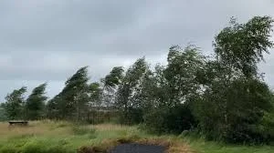
A coastal lane in Co Donegal sits strewn with leaves and broken branches as a yellow weather warning takes hold, the sky low and leaden while gusts push showers inland. The scene captures a compact reality: the entire country is under a Status Yellow wind warning from midnight until 6pm ET on Thursday, and Co Donegal faces a separate Status Yellow rain warning from 6am ET on Thursday until 6am ET on Friday.
What does the Yellow Weather Warning mean for travel?
Short answer: difficult travelling conditions are likely. Met Éireann has set out that strong and gusty southwesterly winds will have the potential to create difficult travelling conditions, with debris or loose objects displaced and some fallen branches or trees expected. The rain warning for Co Donegal warns of spells of heavy rain with possible impacts including spot flooding and poor visibility, further complicating journeys.
Where and for how long will conditions be most severe?
The wind warning covers the entire country from midnight until 6pm ET on Thursday. Co Donegal comes under an additional rain warning from 6am ET on Thursday until 6am ET on Friday. The UK Met Office has also issued a status yellow wind warning for counties Antrim, Armagh, Down, Fermanagh, Tyrone and Derry from 6am ET on Thursday until 12 noon ET. Forecast detail in this period points to fresh to strong and gusty southwesterly winds and outbreaks of rain heavy at times, with the heaviest showers likely in northwestern counties.
Met Éireann has described the approaching pattern as a mobile Atlantic regime that will bring rain or showers each day, turning breezy and cool with some showers at times turning wintry. Snow is possible in areas of higher ground and in the northwest on Thursday evening and Friday, and showers later in the week may fall as sleet or snow in places.
How are authorities framing the forecast and what should people expect?
Met Éireann has issued the Status Yellow warnings and spelled out the main impacts: “difficult travelling conditions, debris or loose objects displaced and some fallen branches or trees. ” For Co Donegal the expected heavy rain carries the additional risks of “spot flooding, poor visibility and difficult travelling conditions. ” The UK Met Office’s separate warning for six northern counties echoes the same concern about strong winds during the morning period on Thursday.
Weather notes in the outlook for the days ahead highlight a mix of rain or showers each day, broken by intermittent drier patches and some sunny spells. Temperatures through the unsettled spell are forecast to be on the cool side, with nights turning colder and the potential for lying snow in west and northwest areas later in the period.
With both wind and rain warnings in force, the combined effect on exposed roads, rural lanes and coastal approaches is underlined by the repeated list of likely impacts. Emergency services and transport operators are preparing for the conditions signalled by these Status Yellow warnings.
As the wind warning moves over the country and the rain warning takes effect in Co Donegal, the simple image at the start—the lane littered with twigs and slick with surface water—takes on a wider meaning. The yellow weather warning is a reminder that a string of brief, intense events can reshape a normal commute and strain local responses, even when the overall forecast also promises drier spells between showers.