The map arrived as a line on a military claim, but on the ground it means something else: a sharper sense of where people can move, where they cannot, and how fragile the new ceasefire feels. In southern Lebanon, the word map now carries the weight of homes, roads, and villages caught between an army’s declaration and the lives still unfolding nearby.
What does the new map mean in southern Lebanon?
Israeli forces say they have established a so-called “yellow line” in southern Lebanon, borrowing a measure Israel has already used in Gaza. The announcement came after a 10-day ceasefire between Israel and Lebanon took effect on Thursday, and it marked the first time the Israeli military has used that phrase in Lebanon.
on Saturday, the military said that in the previous 24 hours its forces, operating south of the Yellow Line, identified people it called terrorists who had violated ceasefire understandings and moved toward the forces from north of the line in a way that posed an immediate threat. The military also said it carried out attacks in response to fighters approaching areas where Israeli soldiers remain stationed in southern Lebanon.
This is where the map becomes more than a boundary marker. It signals a zone defined by military control, movement restrictions, and the possibility of force. In Gaza, Israel’s yellow line has separated territory into different zones, with one area under Israeli military control and another where Palestinians face fewer restrictions on movement. The same language now appearing in Lebanon raises immediate questions about how long such a line can hold, and who pays the price when it does not.
How are people in southern Lebanon experiencing this ceasefire?
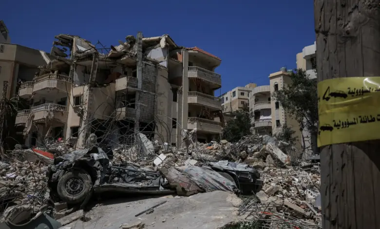
The ceasefire has not brought a full stop to the violence. On Saturday, Israeli artillery hit the southern Lebanese towns of Beit Leif, Qantara and Touline, while the military continued razing homes across several areas. Israel said the actions were taken because of an imminent threat and argued that self-defence and the removal of immediate threats are not restricted by the ceasefire.
That is the gap residents have to live inside: a ceasefire on paper, and continued military action on the ground. The military’s reference to demolitions matters as much as the artillery. Homes are not only damaged in fighting; they are also being erased in ways that can leave families with nowhere to return even if the guns fall silent.
Nour Odeh, an Al Jazeera correspondent reporting from Ramallah in the occupied West Bank, said the announcement appeared to represent the continuation of the “Gazafication” of southern Lebanon. She said Israeli Minister of Defence Israel Katz had instructed the army to demolish Lebanese villages on the border based on the Beit Hanoon and Rafah models, and she said that in Lebanon this may not yet mean expanding the area occupied in southern Lebanon, but that demolition continues. Her comments underline how the map can become a tool of pressure long before it becomes a permanent border.
What are the political stakes behind the line?
Hezbollah Secretary-General Naim Qassem said the 10-day truce cannot continue unless both sides uphold it. read out on television, he said a ceasefire means a complete cessation of hostilities and warned that the resistance fighters will remain in the field with their hands on the trigger and will respond to violations accordingly. He added that there is no ceasefire from the side of the resistance alone; it must be from both sides.
Qassem also demanded a complete Israeli withdrawal from Lebanon. He said the next steps would focus on the release of prisoners and the return of residents to their homes in the border areas. His remarks point to the central tension inside the current moment: a ceasefire that exists, but not yet a shared understanding of what peace, withdrawal, and return should look like.
For families in the border area, that unresolved tension is not abstract. It is the difference between staying away another night or preparing to go home. It is also why this map matters. It is not only a military marker; it is a preview of what life may look like if the border hardens into a lasting line, and whether the ceasefire can become something more than a pause.
As the day ended, the line remained on the military map and in the language of the conflict. For people in southern Lebanon, the more difficult question is what kind of future will be drawn around it.