A thunderstorm warning is in place for Cork, Kerry and Waterford on Saturday, with the strongest impacts expected from midday into the evening. For people planning to travel, work outdoors or simply get through the day, the forecast points to a stretch of weather that could change plans quickly.
What is happening on Saturday?
Met Éireann has issued a status yellow thunderstorm warning for Cork, Kerry and Waterford from 12pm until 7pm on Saturday. A separate status yellow wind and rain warning is also in place for Cork and Kerry from 12pm to 8pm on Saturday.
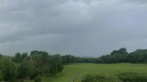
The forecast is for very strong and gusty south to southwest winds, with difficult travel conditions and the potential for fallen trees. There is also the possibility of spot flooding. The west half of the country is expected to see cloudy conditions with scattered showers through the day, and some showers may turn heavy and bring a chance of hail and thunder. In the east, conditions are likely to stay cold but bright and sunny.
How does the thunderstorm warning affect daily life?
For many households, the practical impact will be less about dramatic scenes and more about interruptions: slower journeys, altered plans, and a need to be cautious on roads exposed to wind and rain. The warning matters because even a short burst of severe weather can create knock-on effects, especially where fallen trees or flooding affect routes.
The combination of wind and rain warnings in Cork and Kerry adds another layer of disruption. A status yellow warning does not mean widespread crisis, but it does signal conditions that can make ordinary movement harder and less predictable. For people who commute, deliver goods, or spend time on open roads, that uncertainty can be enough to change the day.
Which counties are under warning and when?
The warning area is focused on the south and southwest, with Cork, Kerry and Waterford covered by the thunderstorm alert. Cork and Kerry are also covered by the wind and rain warning. A separate wind alert for Donegal, Galway, Mayo and Sligo expired at 2pm on Friday, showing that unsettled weather has already been moving through the west and northwest.
In the wider picture, the forecast divides the country into two different experiences: a brighter east and a wetter, more unsettled west. That contrast may make the warning feel local to some and distant to others, but the risks named by Met Éireann are specific enough for affected counties to warrant attention. The thunderstorm risk is part of that sharper edge, especially where showers turn heavy and winds strengthen.
What should people expect from the conditions?
Met Éireann’s guidance points to difficult travelling conditions, fallen trees and spot flooding as the main concerns. In practical terms, that means short-notice delays are possible, and even familiar routes could become more difficult if debris or surface water builds up. The warning period runs through the heart of Saturday afternoon and early evening, which may catch both weekend traffic and people returning home.
The fact that the east is expected to stay cold but bright underlines how uneven the day may be. While some areas will get through Saturday with little disruption, others may see a much more unsettled picture. That split is often what makes a weather warning feel personal: not every county will experience the same thing, but the people in the affected areas have to plan as if they might.
What is the wider message behind the warning?
The wider message is one of caution and timing. The warnings are short in duration, but the impacts could be immediate for anyone on the road or outdoors when the weather turns. For Cork, Kerry and Waterford, Saturday brings the possibility of a fast-changing day shaped by wind, rain and the thunderstorm risk, with the main challenge being to stay flexible as conditions shift.
For now, the scene is not one of calm certainty but of weather that may move quickly between bright spells, heavy showers and stronger gusts. In that kind of Saturday, the difference between a normal day and a disrupted one may come down to when the storm arrives and who is already on the move.