storm dave weather warnings are now in force as Met Éireann extended a yellow wind alert across the country, moving the start to 1pm and stretching the warning through to 2am on Sunday. Winds were already at force 6 and 7 off the coasts of Cork and Kerry on Friday morning, and authorities have listed fallen trees, wave overtopping and difficult travelling conditions among the likely impacts.
What do Storm Dave Weather Warnings mean for drivers and coastal communities?
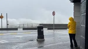
Met Éireann’s yellow wind warning signals strong to gale-force winds, with very strong gusts that can bring fallen trees, damage to property and hazardous driving conditions. Possible impacts named by national agencies include some fallen trees and branches, debris or loose objects displaced, and wave overtopping along exposed shorelines. Combined with heavy rain and high tides, the warning carries a risk of coastal flooding and isolated spot flooding inland.
The Irish Coast Guard is appealing to the public to stay away from coastal edges, harbours, piers and low-lying promenades, particularly during high tide, reflecting concern about wave overtopping and the danger of sudden, powerful surges.
How long will the alert last and who is monitoring the situation?
The extended yellow wind alert runs from 1pm on Saturday to 2am on Sunday; that extension added four hours to an earlier warning. The National Severe Weather and Flooding Coordination Group, which met prior to the alert extension, is continuing to monitor the situation. Forecasting and naming responsibilities sit with national and regional forecasting bodies: the UK Met Office named the storm, and national agencies are tracking its path and impacts.
Western and southern counties are expected to feel the strongest impacts, and local coasts were already experiencing elevated winds at sea. There is also a note of wintry risk farther north: sleet and heavy snowfalls are forecast in Scotland, with the possibility of sleet and hail on higher ground in Ireland as the system moves through.
Practical advice from the authorities focuses on reducing risk: motorists are advised to take care on the roads, plan for difficult travelling conditions and be prepared for debris or fallen branches. Coastal communities are urged to avoid vulnerable waterfront areas at times of high tide when wave overtopping is most likely.
As the situation evolves, the warning may be further extended or upgraded if conditions require it; emergency coordination bodies remain in close watch. For now, the combination of extended hours and already-elevated coastal winds underlines the need for vigilance through the overnight period covered by the alert.
Back where winds were already force 6 and 7 off Cork and Kerry, the extended alert reframes a Friday morning that had the sea and shoreline on watch. Local road users and coastal residents are being asked to heed the guidance of Met Éireann, the Irish Coast Guard and national coordination bodies as storm dave weather warnings remain active and authorities continue to monitor developments.