An alert is in place as unseasonably warm conditions shift toward a brief but potentially damaging round of storms. The first day of spring arrives with warmth, then a cold front sinking south brings breezy winds and scattered showers and thunderstorms after 8: 00 PM Sunday ET, with large hail the primary concern through the night.
Alert: What should people expect Sunday night?
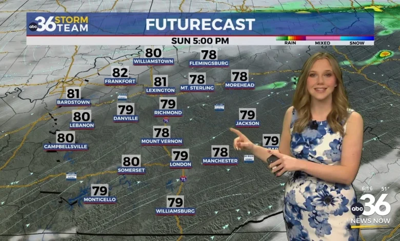
Forecasts indicate the daytime hours will be dry and warm before a cold front moves in. Breezy conditions are expected with wind gusts between 20 and 30 mph. Scattered showers and thunderstorms are likely to arrive after 8: 00 PM Sunday ET. Some of these storms could be strong, with large hail noted as the main threat. If storms develop behind the cold front, the wind and tornado threats are expected to be very low. The hail threat is expected to end by 2: 00 AM Monday ET, and the last of the showers and storms should be gone well before sunrise Monday, giving way to a partly sunny and cooler day.
How will temperatures and conditions evolve through the week?
The pattern begins with warmth tied to the vernal equinox, which occurs at 10: 46 AM Friday ET, and a stretch of unseasonably warm air. Breezy southwest winds will push temperatures into the low 70s on Friday, with a warm front lifting north on Saturday and most locations staying dry though a few isolated showers or storms could develop near the Kentucky-Tennessee border. The warmest air arrives over the weekend, with readings soaring into the low to mid 80s — described as roughly 15 to 25 degrees above normal for mid-March. After the late-Sunday system moves through, temperatures will fall back toward normal, with highs only in the 50s on Monday and a recovery to around 60 degrees by Tuesday and near 70 degrees by Wednesday ET.
What are the broader storm risks and the outlook beyond Monday?
Attention shifts to a stronger system expected to move in late Sunday into early Monday. As warmer and slightly more humid air builds in, conditions may become favorable for thunderstorms along the approaching cold front. Some storms could become strong, with the potential for gusty winds, hail, and possibly a brief tornado in portions of the region. Level 1 and Level 2 severe weather risks are noted for northwest portions of the Bluegrass, though confidence in severe weather remains somewhat uncertain. After the front passes, mainly drier and cooler conditions are expected through the early part of the week, with rain and storm chances increasing again toward the middle of next week as another front approaches.
Practical timing details from the forecast: temperatures will only fall into the 60s by Sunday morning, meaning no jackets will be needed for the overnight and daytime warmth leading into Sunday. Showers and storms are expected after 8: 00 PM Sunday ET, with the main hail threat ending by 2: 00 AM Monday ET. The last showers should clear before sunrise Monday, leaving a partly sunny, cooler day with highs only in the 50s.
The sequence — a warm start tied to the vernal equinox, a late-Sunday cold front with a night of hail-focused storms, followed by a brief cool down and a midweek rebound — defines the week’s weather story for communities across the Bluegrass. Residents are advised to monitor local updates for timing and impacts as confidence in specific severe outcomes remains uncertain.